


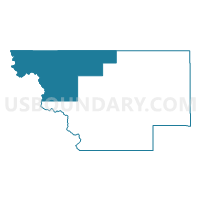
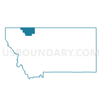
Precinct 15, Glacier County, Montana
About
Outline

Summary
| Unique Area Identifier | 612039 |
| Name | Precinct 15 |
| County | Glacier County |
| State | Montana |
| Area (square miles) | 732.38 |
| Land Area (square miles) | 710.61 |
| Water Area (square miles) | 21.77 |
| % of Land Area | 97.03 |
| % of Water Area | 2.97 |
| Latitude of the Internal Point | 48.90021740 |
| Longtitude of the Internal Point | -113.53514210 |
Maps

Graphs
Select a template below for downloading or customizing gragh for Precinct 15, Glacier County, Montana


Neighbors
Neighoring Voting District (by Name) Neighboring Voting District on the Map
- Precinct 14, Glacier County, MT
- Precinct 17, Flathead County, MT
- Precinct 19, Glacier County, MT
- Precinct 9, Glacier County, MT
Top 10 Neighboring County Subdivision (by Population) Neighboring County Subdivision on the Map
- Blackfeet Reservation CCD, Glacier County, MT (9,560)
- Glacier National Park CCD, Glacier County, MT (37)
- Glacier National Park CCD, Flathead County, MT (31)
Top 10 Neighboring Place (by Population) Neighboring Place on the Map
Top 10 Neighboring Elementary School District (by Population) Neighboring Elementary School District on the Map
- Columbia Falls Elementary School District, MT (14,331)
- Browning Elementary School District, MT (8,320)
Top 10 Neighboring Secondary School District (by Population) Neighboring Secondary School District on the Map
Top 10 Neighboring State Legislative District Lower Chamber (by Population) Neighboring State Legislative District Lower Chamber on the Map
Top 10 Neighboring State Legislative District Upper Chamber (by Population) Neighboring State Legislative District Upper Chamber on the Map
Top 10 Neighboring 111th Congressional District (by Population) Neighboring 111th Congressional District on the Map
Top 10 Neighboring Census Tract (by Population) Neighboring Census Tract on the Map
- Census Tract 9404, Glacier County, MT (4,330)
- Census Tract 1, Flathead County, MT (3,255)
- Census Tract 9800, Glacier County, MT (24)